|
|
|
|

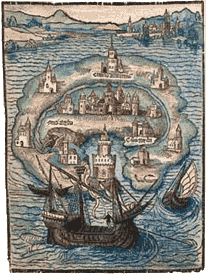
Woodcut map from the 1516 edition of Utopia.
Excerpt from Utopia, Book 2.
[DESCRIPTION OF THE ISLAND OF UTOPIA]
 The island of Utopia is 200 miles broad in the middle, and over a great part of it, but grows narrower at either end. The figure of it is not unlike a crescent. Eleven miles breadth of sea washeth its horns and formeth a considerable bay, encompassed by a shore about 500 miles in extent, and well sheltered from storms. In the bay is no great current. The whole coast is as it were a continued harbour, affording the whole island every advantage of mutual intercourse. Yet the entrance into the bay, owing to rocks and shoals, is very dangerous.
In the middle is a rock which appeareth above water, on whose top is a tower inhabited by a garrison. The other rocks lie under water, and are very dangerous. The channel is known only by the natives, and a stranger entering the bay without one of their pilots would be in imminent danger of shipwreck. Themselves could not pass it in safety, without certain marks on the coast to direct their way. And if these were a little altered, any fleet coming against them, however large, would certainly be lost. On the other side of the island are likewise many harbours; and the coast is so fortified by nature as well as art, that a small force could hinder the descent of a large army.
 Report saith (and marks of its credibility remain) that this island was originally a part of the continent. Utopus, the conqueror of it, and whose name it now bears (having previously been called Abraxa), brought the government and civility of the rude inhabitants to their present highly improved state. Having easily subdued them, he formed the design of separating them from the continent and encompassing them with the sea. To this end, he ordered a deep channel to be dug 15 miles long; and that the natives might not think he treated them like slaves, he not only obliged them, but also his own soldiers to labour at the work. From the number of hands employed, it was finished with dispatch exceeding every man's expectation; and his neighbours, who at first laughed at the folly of the undertaking, when they saw it accomplished, were struck with admiration and terror.
There are 54 cities in the island, all of them large and well built. Their laws, manners, and customs, are the same, and they resemble each other as nearly as the ground they stand on will allow. The nearest to each other are at least 24 miles asunder; and the most remote, not above a day's journey on foot. Every city sendeth three of her wisest senators once a-year to Amaurot (the capital of the island, and situate in the center), to consult on their common interests. The jurisdiction of every city extendeth at least 20 miles, and farther where they lie wider asunder. No one desireth to enlarge her boundary, for the people consider themselves in the light of good husbands, rather than owners, of their lands.
Cayley, Arthur, the Younger, ed. Memoirs of Sir Thomas More, &c.. Vol II.
London: Cadell and Davis, 1808. 55-57.
 |
to the Works of Sir Thomas More |
Site copyright ©1996-2018 Anniina Jokinen. All
Rights Reserved.
Created by Anniina Jokinen
on June 1, 2009. Last updated December 11, 2018.
|
|
The Tudors
King Henry VII
Elizabeth of York
King Henry VIII
Queen Catherine of Aragon
Queen Anne Boleyn
Queen Jane Seymour
Queen Anne of Cleves
Queen Catherine Howard
Queen Katherine Parr
King Edward VI
Queen Mary I
Queen Elizabeth I
Henry Fitzroy, Duke of Richmond
Renaissance English Writers
Bishop John Fisher
William Tyndale
Sir Thomas More
John Heywood
Thomas Sackville
Nicholas Udall
John Skelton
Sir Thomas Wyatt
Henry Howard
Hugh Latimer
Thomas Cranmer
Roger Ascham
Sir Thomas Hoby
John Foxe
George Gascoigne
John Lyly
Thomas Nashe
Sir Philip Sidney
Edmund Spenser
Richard Hooker
Robert Southwell
Robert Greene
George Peele
Thomas Kyd
Edward de Vere
Christopher Marlowe
Anthony Munday
Sir Walter Ralegh
Thomas Hariot
Thomas Campion
Mary Sidney Herbert
Sir John Davies
Samuel Daniel
Michael Drayton
Fulke Greville
Emilia Lanyer
William Shakespeare
Persons of Interest
Cardinal Thomas Wolsey
Archbishop Thomas Cranmer
Thomas Cromwell
John Fisher, Bishop of Rochester
Cardinal Lorenzo Campeggio
Cardinal Reginald Pole
Stephen Gardiner, Bishop of Winchester
William Tyndale
Pico della Mirandola
Desiderius Erasmus
Christopher Saint-German
Thomas Linacre
William Grocyn
Hugh Latimer
Elizabeth Barton, the Nun of Kent
For more, visit Encyclopedia
Historical Events
Field of the Cloth of Gold, 1520
Pilgrimage of Grace, 1536
The Babington Plot, 1586
The Spanish Armada, 1588
Government
Oath of Supremacy
The Act of Supremacy, 1534
The First Act of Succession, 1534
The Third Act of Succession, 1544
The Ten Articles, 1536
The Six Articles, 1539
The Second Statute of Repeal, 1555
Images of London:
London in the time of Henry VII. MS. Roy. 16 F. ii.
London, 1510, earliest view in print
Map of England from Saxton's Descriptio Angliae, 1579
Location Map of Elizabethan London
Plan of the Bankside, Southwark, in Shakespeare's time
Detail of Norden's Map of the Bankside, 1593
Bull and Bear Baiting Rings from the Agas Map (1569-1590, pub. 1631)
Sketch of the Swan Theatre, c. 1596
Westminster in the Seventeenth Century, by Hollar
Visscher's Panoramic View of London, 1616. COLOR
For more, visit Encyclopedia
|
|